ALTA / NSPS Standards is for surveyors who already know the drone can help on ALTA work and want Aerotas to push the aerial portion closer to finished deliverable quality.
Instead of making your team start from a more general linework package and then adapt it for ALTA needs, this product is scoped around that end use from the beginning.
Best Fit
Choose this product when the project is clearly headed toward an ALTA / NSPS survey.
- You want drone-collected visible data aligned more closely to ALTA workflows.
- You need to reduce office cleanup between aerial drafting and final ALTA production.
- You want Table A-related scope conversations handled earlier and more clearly.
Important limitation: this product gets you closer to the finished ALTA deliverable. It is not, by itself, a completed ALTA / NSPS Land Title Survey.
What makes this different from Full Linework
Aerotas developed this product because standard drafting, while useful, can still leave meaningful work between a typical drone deliverable and a finished ALTA package. ALTA / NSPS Standards closes more of that gap.
Compared with standard Full Linework, this product applies additional drafting and marking decisions aimed at ALTA workflows. Legacy Aerotas product language also highlights options for relevant Table A items where they apply.
What it is designed to include
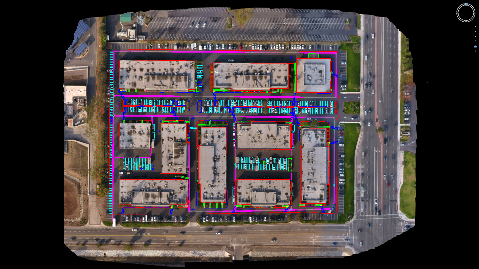
- Visible planimetric features captured from the air
- Additional curb and wall line support where appropriate
- Drafting and layer decisions intended to better align with ALTA production needs
- A deliverable package that reduces the amount of translation from drone data into ALTA support work
In many projects, the value is not that the drone solves the whole survey. The value is that it handles more of the visible-site information cleanly and consistently, so your licensed team can spend more time on the work that truly must be done on the ground.
Commercial ALTA support
This product is designed for the kind of office and site work where cleaner aerial drafting materially shortens the path to the final survey package.
Closer to ALTA-ready output
The product exists to reduce the gap between standard drone linework and the stricter structure expected on ALTA jobs.
When this product is the right fit
- Commercial and development sites where ALTA support work is needed
- Projects where visible feature extraction from the air can materially reduce office drafting time
- Teams that already know they are building toward an ALTA deliverable and want the drone component scoped correctly upfront
How to think about the value
ALTA jobs are won by removing unnecessary work without losing defensibility. This product is built around that idea. Aerotas is not claiming the drone can do everything. Aerotas is claiming the drone can do more of the useful work correctly when the deliverable is scoped around ALTA realities from the start.
If you need a broader general-purpose site map, Full Linework may still be the right default. If the project is clearly ALTA-oriented, this is usually the better buy.
Next Step
Bring ALTA scope details into the quote request early.
That is how you avoid buying a generic deliverable first and then paying your internal team to reshape it later.